The MTHL-Metro Link project you’re referring to is a significant development aimed at enhancing connectivity and transportation infrastructure in the Mumbai Metropolitan Region (MMR). Here’s a detailed breakdown of the proposed project and its advantages:
Overview of MTHL-Metro Link
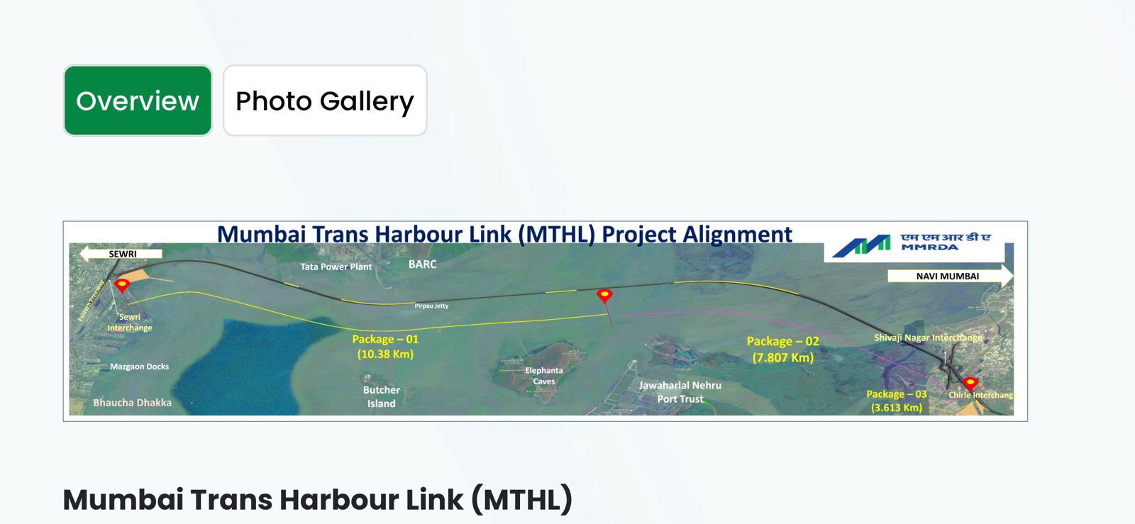
The Mumbai Trans Harbour Link (MTHL) is a sea bridge project that will connect Mumbai’s mainland to Navi Mumbai, while also facilitating a Metro corridor that will run from Prabhadevi (in Mumbai) to Sewri and further extend to the mainland, including key locations in Navi Mumbai and on the Panvel-Pen section. The goal is to have interchange stations and facilities with the existing and proposed rail systems, making it easier for commuters to switch between different modes of transport (such as metro, local trains, and long-distance trains).
Advantages of the
-
Induce and Accelerate Development on the Mainland:
- Development Growth: The establishment of this metro corridor is expected to accelerate urban development in the mainland, especially in the areas that will now be easily accessible. Areas along the metro corridor will likely see increased residential, commercial, and industrial growth due to improved connectivity. Navi Mumbai, in particular, will benefit from better access to Mumbai, which will lead to real estate development and commercial investment.
- Catalyst for New Business: Easy transport connections will also attract businesses looking to set up operations in the less crowded, more affordable mainland, spurring job creation and fostering a new business ecosystem.
- Increased Accessibility: The metro will significantly improve connectivity to underserved areas that were previously not easily accessible by public transport, enhancing the overall livability of the region.
-
Encourage Mass Transport and Cater to Future Travel Demand:
- Future Demand Accommodation: The MTHL Metro corridor is being planned with future travel demand in mind. As the population in the MMR continues to grow, the demand for mass transport will increase, particularly in outlying areas like Navi Mumbai, Panvel, and Pen. The metro will address this need by providing a reliable, fast, and comfortable alternative to road-based transport.
- Promote Sustainable Transport: This project is part of an overall shift towards sustainable mass transit systems, reducing the dependency on cars, which contributes to traffic congestion and pollution. By expanding the metro network, the system will offer commuters a greener alternative.
- Reduction in Road Traffic: By providing a fast and efficient metro option, it will encourage more people to use public transport rather than drive, which will help reduce traffic on roads, especially in high-traffic areas like Prabhadevi, Sewri, and the upcoming Navi Mumbai extension.
-
Facilitate Decongestion of Other Passenger Transport Systems and Save Fuel Consumption:
- Reduced Congestion on Existing Systems: One of the most important advantages of the MTHL-Metro Link is that it will help decongest existing transport systems, such as local trains and buses. Mumbai’s local train network is notoriously overcrowded, and the metro will alleviate some of that pressure by offering a more efficient alternative. The metro will also help reduce overcrowding on key roads that connect major areas like South Mumbai and Navi Mumbai.
- Fuel Consumption and Environmental Impact: By promoting the use of metro transport instead of private vehicles, the MTHL-Metro Link will lead to a reduction in fuel consumption. Fewer private cars on the road means less petrol/diesel consumption and lower emissions, contributing to the reduction of air pollution in the city.
- More Efficient Passenger Movement: The metro will offer faster travel times, particularly when compared to road traffic, saving valuable commuting time for passengers. This will improve overall efficiency for people who rely on public transport.
Key Features and Goals of the MTHL-Metro Link Project:
-
Seamless Integration with Existing Rail Systems:
- The metro corridor will include interchange stations that will allow easy transfers between different modes of transport, such as the existing local train services, suburban trains, and the proposed metro network.
- The connection with the Mumbai Trans Harbour Link (MTHL) will make it easier for people traveling from Navi Mumbai and the Panvel-Pen section to seamlessly connect to the mainland Mumbai metro stations, improving commuter convenience.
-
Improved Access to Key Locations:
- The metro extension will provide direct access to critical locations like Navi Mumbai and Panvel, areas that are expected to experience increased development due to the improved connectivity.
-
Sustainability and Modernization:
- The MTHL-Metro Link will help Mumbai move towards more sustainable urban development, modernizing its transport infrastructure and making it more environmentally friendly.
- The proposed metro will be equipped with advanced technology to ensure high efficiency, reliability, and safety for commuters.
Conclusion:
The MTHL-Metro Link project is a visionary infrastructure development that will significantly transform how people travel in Mumbai and its neighboring regions. By improving access, reducing congestion, and encouraging the use of mass transport, the project will help Mumbai manage its growing population and traffic challenges more effectively. The proposed corridor not only serves the immediate needs of transportation but also sets the stage for future urban growth, making it a key element in Mumbai’s long-term development strategy.
1.Length wise distribution (Total length : 49.60 Km)
Phase I – (Siddhivinayak – Dhutam)
- Underground portion: 3.985 Km
- Main Bridge length: 16.160 Km
- Elevated Portion: 5.675 Km
- At Grade: 2.080 Km
Phase II – (Dhutam – Dushmi)
- At Grade 27.90 Km
- Total Length: 49.600 Km
2.Stations Distribution (Total No. of stations: 20 nos.):
Phase I – (Siddhivinayak – Dhutam)
- Underground station: 04
- Relief Centre: 01
- Elevated portions: 02
- At grade: 01
Phase II – (Dhutam – Dushmi)
- At Grade 12
- Total Number Stations 20
3.Depot / Maintenance Facility:
- Depot Locations Size
- Dhutam: 46.35 Ha
- Dushmi: 13.34 Ha
- The proposed alignment is as shown below:
-
The proposed alignment you’re describing seems to be for a large-scale urban infrastructure project, likely a metro or light rail system. Here’s a detailed breakdown of the information based on the sections you provided:
1. Length-wise Distribution:
Total Length: 49.60 Km
The total length of the system, which could be for a metro or a similar transport project, is 49.60 kilometers. This total length is divided into two phases, which consist of various types of sections (underground, elevated, at grade) and structures (bridges, stations, etc.).
Phase I: Siddhivinayak – Dhutam
This is the first part of the alignment.
-
Underground portion: 3.985 Km
- This refers to the portion of the track that will run underground. It spans 3.985 kilometers, indicating that the system will be subterranean for this section, likely to avoid surface-level congestion and to protect the environment or urban infrastructure above ground.
-
Main Bridge length: 16.160 Km
- A significant portion of this phase will run over a main bridge, stretching 16.16 kilometers. This could be due to the need to cross large bodies of water, valleys, or densely built-up areas where underground or elevated structures are not feasible or are too expensive.
-
Elevated Portion: 5.675 Km
- The elevated portion covers 5.675 kilometers. These sections would be constructed above ground level, likely using piers and beams. Elevated sections are often preferred where the ground is congested or where underground construction is too costly or difficult.
-
At Grade: 2.080 Km
- The at-grade section, covering 2.080 kilometers, refers to portions of the system that run at the same level as the surrounding land, as opposed to being elevated or underground. These segments are typically used where there is open space or low-density development.
Phase II: Dhutam – Dushmi
This is the second phase of the project.
- At Grade: 27.90 Km
- The at-grade section in this phase is considerably longer at 27.90 kilometers. This suggests that the route in this phase may be designed to run through less urbanized or more open areas where an elevated or underground solution isn’t necessary.
2. Stations Distribution:
The system has 20 stations in total, and they are distributed across the two phases of the project.
Phase I: Siddhivinayak – Dhutam
-
Underground stations: 04
- There will be 4 underground stations along the underground portion of the system. These stations are likely designed to be deep beneath the ground and will serve densely populated or central areas where surface-level space is scarce.
-
Relief Centre: 01
- A relief center is mentioned, which could be a facility for maintenance, operations, or emergency response. It could provide services to ensure the proper functioning of the system, such as storage for spare parts, staff quarters, or operational headquarters.
-
Elevated stations: 02
- 2 stations will be located along the elevated portions. These stations are likely to be situated at ground level but are elevated to provide access to commuters. They could serve important areas that need elevated construction due to heavy traffic or urban density.
-
At-grade station: 01
- There is 1 station at ground level. This could be located in a more suburban or low-density area where an elevated or underground station isn’t necessary.
Phase II: Dhutam – Dushmi
- At-grade stations: 12
- In this phase, 12 stations will be located at grade level, likely serving a more spread-out, suburban, or rural region. At-grade stations are simpler to construct and less costly than elevated ones, making them suitable for these areas.
3. Depot / Maintenance Facility:
A Depot and Maintenance Facility will be established in two locations:
-
Dhutam Depot: 46.35 Ha
- This depot will occupy 46.35 hectares of land. Depots are essential for the storage and maintenance of trains or other vehicles, as well as for personnel facilities. This size indicates that it is likely a large facility with capacity to accommodate multiple trains, maintenance workshops, and potentially a training center.
-
Dushmi Depot: 13.34 Ha
- The Dushmi depot is smaller, covering 13.34 hectares. This could be a secondary depot, possibly serving a smaller fleet or used primarily for storage or smaller-scale maintenance activities compared to the Dhutam depot.
Summary of Key Features:
- The total length of the system is 49.6 km, divided into two phases.
- The first phase includes underground, elevated, and at-grade portions, with a focus on a large bridge (16.16 km).
- The second phase largely consists of at-grade portions, reflecting a potentially less dense or more suburban area.
- The system has 20 stations, with varying numbers of underground, elevated, and at-grade stations in each phase.
- There will be two main depots, one significantly larger than the other.
The alignment and station distribution suggest a blend of infrastructure approaches to maximize efficiency, minimize costs, and meet the transportation needs of both urban and suburban areas.
-